ITINERARY|MADE

Iberian Peninsula
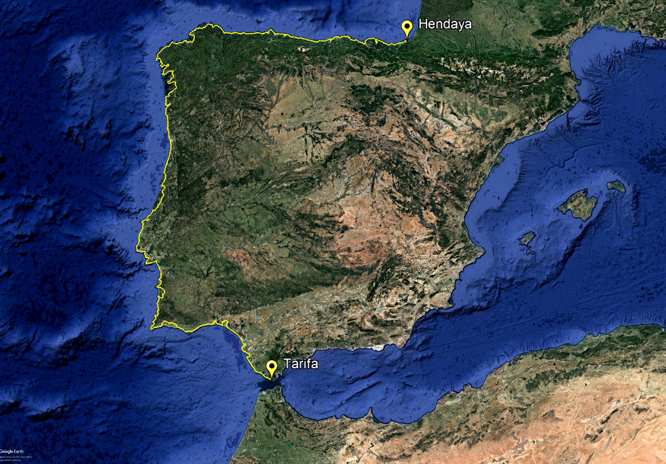
An itinerary that took us to cover 3,457 km and more than 35,000 meters of accumulated difference in altitude through traditional paths such as the Vicentina Route, the Camiño da Costa, O Camino dos Faros in Costa da Morte or the Camino Norte to Santiago. Documenting more than 250 beaches scattered along the peninsular Atlantic coast and surfing on some of them.
We started in Algeciras to reach the town of Tarifa, the southernmost point in Europe, where we traveled along the coast of Cadiz and the coast of the province of Huelva. We crossed the mouth of the Guadiana River, the natural Spanish-Portuguese border, thus accessing Portugal, where we traveled through the Algarve region to the cape of Sao Vicente.
From this point we set the compass heading north along the entire Portuguese coast and the provinces of Beja, Setubal, Lisbon, Nazaré, Coimbra, Aveiro, Porto, Braga and finally Viana do Castelo, the last province before crossing the natural border that marks the mouth of the Minho River. Giving us access to the province of Pontevedra and the Rías Baixas region that goes from the Ría de Vigo to Punta Carreiro. Next we toured the wild Costa da Morte, which stretches from Cape Finisterre, known in Roman times as the end of the world, to Malpica.
At this point we gave way to the incredible Rías Altas, which includes the province of A Coruña and the coast of Lugo up to the border with Asturias. At this point we changed our course to the east and that would take us to cover the entire north coast that bathes the Cantabrian Sea, crossing the coasts of Asturias, Cantabria and the Basque Country to Irún / Hendaye, the Spanish-French border.

France
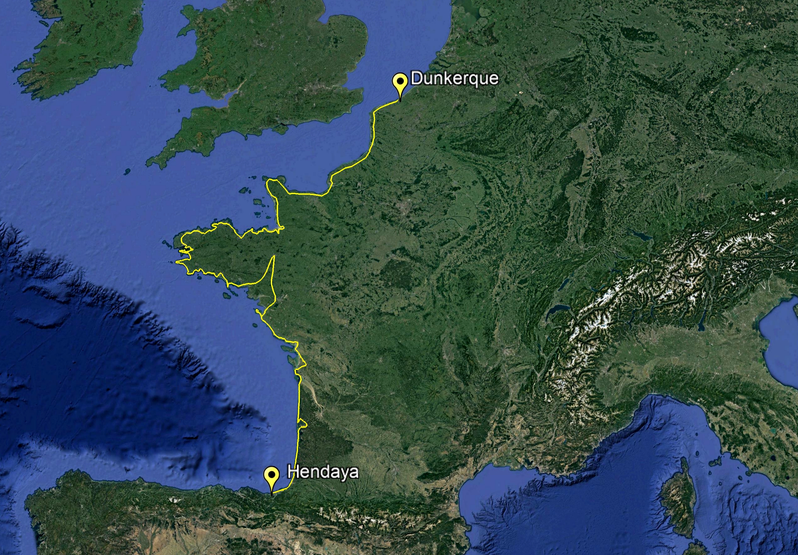
We have traveled the Atlantic Coast of France in 48 stages, with a total of 3,048 km and more than 17,000 meters of accumulated elevation gain, documenting more than 150 beaches. We depart from Hendaye to the border with Belgium, located 14 km from the historic city of Dunkirk.
The first part to the city of Nantes we followed "la Velodyssee", a perfectly signposted route that is part of the Euro Velo 1 route. At the height of Nantes we decided to go up to Rennes, the capital of Brittany, due to our interest in discovering its idyllic interior, to descend again to the coast. From this point, thanks to the GPS, different maps and various coastal routes, we started spinning the itinerary to reach the Franco-Belgian border.
We started in Hendaye, heading north, through the commune of New Aquitaine, entering the P. Natural des Landes, which represents the largest forest in continental Europe. We pass the city of Bordeaux and cross the Gironde estuary, where the Garonne river flows, to go further north into marshlands, thus entering the Poitevin Marshes Natural Reserve and the Pays de Loire commune. All these territories comprise a coastline made up of long and endless sandbanks that are bathed by the Atlantic.
Once we entered the commune of Bretagne, the morphology of the coast changed, being steeper and with much smaller sandbanks. This commune has with Raz Cape, the most western point of France. Its peninsula shape means that it has a south, west and north coast. We leave Brittany with the mythical Mount St Michel, thus entering Normandy, where part of its coast is full of recent history due to the Normandy landings, with an area of marshes or its emblematic white cliffs that it shares with its neighboring south coast of England. Finally we enter the Haute France commune, returning to a coast of long sandbanks up to the border with Belgium.
PENDING|ITINERARY

Belgium-Netherlands-Denmark-Norway
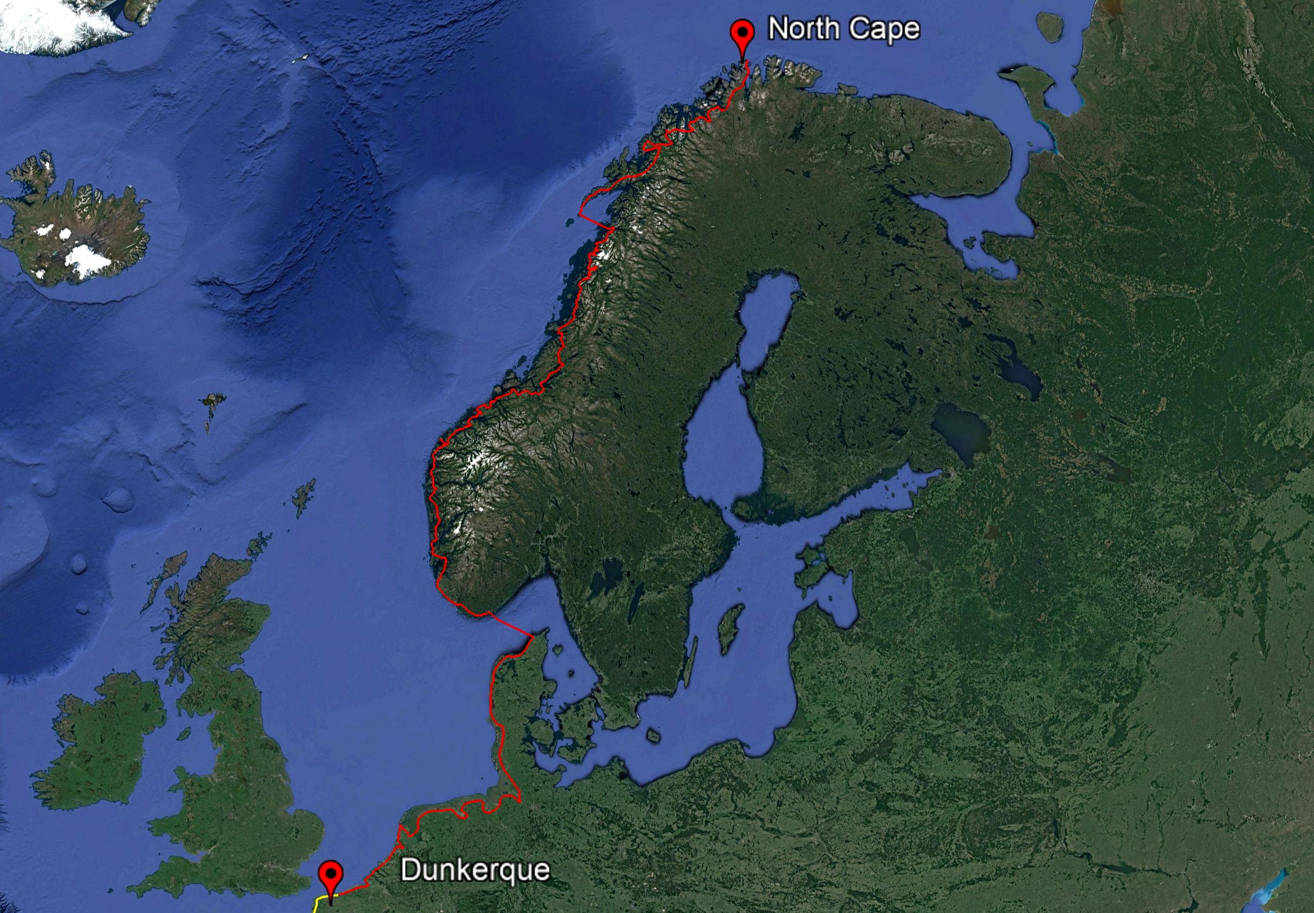
According to our calculations, we would have around 7,000 km and 50,000 meters of accumulated elevation gain left to reach our goal, the North Cape. To do this, we will return to the Franco-Belgian border to cross the coasts that bathe the North Sea.
We will start in Belgium and continue through the Netherlands, to cross into Germany at the mouth of the Ems River and continue north to the tip of Hirtshals in northern Denmark, where we will take a boat to Kristiansand in southern Norway. So far we will find a flat terrain without too many complications.
We are aware from our experience, that it is very different when you plan from home to when you are really on the ground, so we will remain open to what the road holds for us, and we will be happy to continue sharing it with you.
